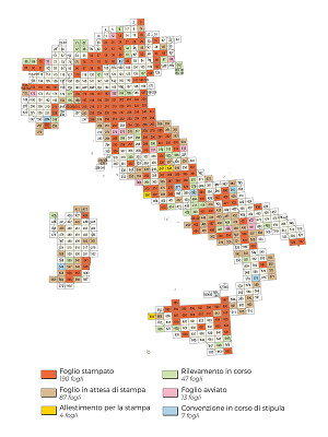
Implementation status
Since the end of the 80's state resources have been made available to allow the start of the "CARG Project" for the realization and computerization of the new official geological map at 1:50.000 scale. The Geological Survey of Italy (SGI) has signed 63 agreements and 29 program agreements with about 50 structures between Regions and Autonomous Provinces, Universities and CNR organs, for the production of:
- 348 Geological sheets;
- 36 Thematic maps: geomorphological, hydrogeological, geological hazard related to slope stability, 3 maps related to flood events in Piemonte (November 1994) at other scales;
- 6 Geology sheets of the Adriatic continental shelf at the scale 1:250,000;
- 1 Morphobatimetric map of the Tyrrhenian basin;
- part of the CROP transept;
- 26 Prototype maps;
- maintenance and integration of the Geological Database;
- updating of the Catalogue of geological formations.
The Project is characterized by the use of national technical regulations, specifically drawn up by the SGI with the collaboration of experts and published in the series of the Geological Survey Quaderni. They constitute the reference guidelines for the survey, cartographic representation and computerization of both geological and geothematic sheets, allowing their homogeneity at the national level.
The geological data collected are computerized and constitute the geological database of ISPRA.
In addition to the survey of the emerged lands (essentially carried out at a scale of 1:10,000, summarized first at a scale of 1:25,000 and then at a printing scale of 1:50,000), with the CARG Project the submerged part of many coastal sheets is also surveyed; the geological survey of 6 geological sheets of the continental shelf in the Adriatic area was also carried out; moreover, in the realization of the sheets a particular attention has been requested to the survey of the continental Quaternary.
IMPLEMENTATION STATUS OF GEOLOGICAL MAPS FUNDED UNDER THE PROJECT CARG
348 Geological maps
- 190 printed
- 87 ready to print
- 4 in preparation for printing
- 47 in process of survey
- 13 sheet started
- 7 agreements in the process of being concluded
The Geological sheets, the Geothematic sheets and the Marine Geology sheets at 1:250.000 scale - printed, waiting for printing and in preparation for printing - realized within the CARG Project and the Geological and Geothematic sheets realized by the Geological Survey of Italy, can be consulted on the website of the Department of Soil Defence - Geological Survey of ISPRA.
Currently, 265 Geological sheets, 25 of the underground, 32 geothematic and 12 of marine geology at the scale 1:250.000 have been inserted. The site is constantly updated.

