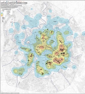
Map of the underground cavities of Rome
There are many archaeological and geological-geotechnical studies concerning underground cavities in the territory of Rome. These cavities constitute an intricate network of tunnels under the city, forming systems, sometimes multi-storey, which are deepened at different depths. These voids are all of anthropogenic origin, dug in various ways, for various purposes (building, plumbing, religious etc.), but mostly for the procurement of building materials. The Roman quarries were mainly built in volcanic soils. They are the most widespread cavities and are mainly concentrated in the eastern portion of the city. Mineral cultivation took place through the construction of tunnels that provided an entrance to the base of the slope. The use of tuff quarries as areas of worship and cemeteries is successive and dates back to the I-III century A.C. century. The areas surveyed and used as private catacombs and hypogea represent the second type of underground cavity by extension. The conglomerate and sand quarries, built in the south-western part of the city, have lesser extension and were never used as necropolis but, later, as deposits, mushroom farms, etc. Unfortunately, this network of underground tunnels is known only in fragmentary form and many civilian homes have been built on such emptinesses, unknown and uncontaminated vacuums. The presence of underground cavities in particular conditions, together with the possible losses of the hydraulic network of the underground utilities, can cause the collapse of the most superficial layers of the ground with the formation of chasms on the surface (anthropogenic sinkholes) determining risk for the precious Roman urban fabric. So far, there has been an overall cartography and a complete database that show the actual extension of the cavities. However, this information is now fundamental in order to study the dangerousness of the territory. In order to improve and complete the study and census of the underground voids, a Working Group has been set up within ISPRA (in which various bodies participate, among which: Roma Capitale, CNR, National Civil Protection, Roma Metropolitane and the main Speleological Associations of Rome and the Pontifical Commission of Sacred Archeology) which is involved in data collection. In this way, at the punctual data have been added the mapping of the cavities in an areal form. The first results obtained by the working group and the first map of the underground cavities of Rome are therefore here presented. This map is not error-free, it is still being processed and perfected.
- Carta delle cavità sotterranee di Roma (21.5 Mb)
- Carta delle cavità sotterranee di Roma - Quadrante 1 (15.0 Mb)
- Carta delle cavità sotterranee di Roma - Quadrante 2 (19.9 Mb)
- Carta delle cavità sotterranee di Roma - Quadrante 3 (14.0 Mb)
- Carta delle cavità sotterranee di Roma - Quadrante 4 (17.8 Mb)

